More than 90 George Washington University undergraduate and graduate students helped the World Bank and the U.S. Agency for International Development (USAID) map an entire city with just the click of a mouse last Friday night.
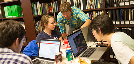
Students taking Geographical Information Systems courses gathered in Old Main for a Mapathon. The three-hour voluntary event required students to use OpenStreetMap, a free mapping platform that many describe as a cross between Google Earth and Wikipedia. OpenStreetMap enables users across the globe to collect data points and aerial photography, and then tag specific locations to create editable maps of the world. The data is free and open for all users to download or extract.
Nuala Cowan, an assistant professor in the Department of Geography and director of the Geographical Information Systems graduate certificate program, helped organize this year’s Mapathon after partnering with USAID, the World Bank and Kathmandu Living Labs in an initiative to map Kathmandu. She worked with GW Spatial Analysis Lab Manager Richard Hinton and Professors Michael Mann, Joseph Dymond and Nate Smith from the Department of Geography to put the exercise together.
The city of Kathmandu is vulnerable to earthquakes, and organizations have been working to get one step ahead of a natural disaster by using maps to draft emergency preparedness plans early. Kathmandu is located in a valley that is difficult to get to, so experts are analyzing ways to get resources into the city and make search-and-rescue procedures easier. Ms. Cowan explained that while the students’ mapping will help with disaster relief, people of Kathmandu might also use the data for day-to-day needs.
“This can be used by the community for pretty much anything—local people might turn to it for orientation. But our partners plan to use it for disaster planning purposes. They’re going to work with the U.S. Geological Survey to do some earthquake modeling and to quantify debris,” Ms. Cowan said.
Ms. Cowan has been guiding students through mapping projects for four years. In the past, she and her GW colleagues have worked with organizations like the Red Cross to help trace maps in Colombia, Bangladesh and Indonesia.
Students were assigned 150 pieces of infrastructure—buildings, roads and courtyards—to trace using the OpenStreetMap software. The Mapathon offered students the chance to knock the work out in three hours while engaging with their classmates and professionals from USAID and the World Bank.
Once students complete their work, Kathmandu Living Labs will send on-the-ground members to validate buildings and correct any discrepancies. The project is especially focused on identifying schools, hospitals and other corridors that could help if an earthquake were to occur.
Tracing infrastructure in OpenStreetMap can get difficult. Students are required to look at aerial photos of certain parts of Kathmandu and identify what is depicted. Sophomore James Lafaso pointed to a blurry gray square on his screen, unable to decipher exactly what it represented.
“One of the challenges is figuring out what these objects are—I can’t tell if that’s a building or a courtyard,” he said.
Luckily, several USAID and World Bank professionals floated around each computer, answering questions and trying to help students navigate through difficult parts of their mapping. USAID’s Shadrock Roberts, principal GIS analyst, and Chad Blevins, geospatial coordinator, were pivotal to the project. They led trainings before the event and assisted students at the Mapathon.
“There’s so many people here who know exactly what they’re doing,” sophomore Zoe Jenkins said. “This is more hands-on—and better than writing a paper.”
After helping several students with their assignments, Carrie Stokes, director of the GeoCenter at USAID, provided a thank you and a few brief remarks.
“What you’re actually doing is creating real data, and you’re creating real data for a part of the world that doesn’t have it and really needs it,” she told students. “We’re inspired by your efforts to come out on a Friday night, and I think this energy you have brought here is going to be felt the world over.”
Ms. Cowan and Mr. Hinton are currently working to develop an educational program that professors in different departments can use to get students mapping in other parts of the world. They gave a mapping training to a handful of faculty, graduate students and Georgetown University students interested in taking part of the Mapathon. Ms. Cowan said teaching everyone to use OpenStreetMap’s software can have a worldwide impact.
“We’re trying to make it by where it’s not exclusive to geographers, because maps are important to everybody. Maps have a huge role in social empowerment, and they have a huge role in development,” Ms. Cowan said.